
Planning a safari around the great wildebeest migration requires more than booking a camp and hoping the herds show up. The migration covers an enormous landscape spanning two countries, multiple ecosystems, and dozens of distinct wildlife zones — and understanding how this landscape is organized gives safari travelers a decisive advantage when choosing where to go and when to go there. A detailed Mara Serengeti map transforms the migration from an abstract wildlife event into a concrete, navigable journey that travelers can plan around with precision and confidence. This article breaks down everything the map reveals — the major zones, the key river crossing points, and the migration routes that define the 2026 safari season — so you can make the most informed travel decisions possible.
Why the Map of the Mara Serengeti Ecosystem Matters for Safari Travelers
The Mara Serengeti ecosystem is not a single destination — it is a vast, interconnected landscape that stretches from the short-grass plains of southern Tanzania all the way to the rolling hills of southwestern Kenya. The entire ecosystem covers more than 40,000 square kilometers when you include all the national parks, game reserves, and conservation areas that form the protected wildlife corridor. Without a clear understanding of how this landscape is organized, safari travelers often make booking decisions based on incomplete information — ending up in the wrong zone at the wrong time of year and missing the wildlife experiences they traveled thousands of kilometers to witness.
A detailed mara serengeti map shows you exactly how the ecosystem divides into distinct zones, where the major rivers run, which crossing points the wildebeest use most frequently, and how the migration route flows from south to north and back again throughout the year. This geographic knowledge empowers travelers to align their safari dates and camp locations with the specific phase of the migration that interests them most — whether that is the calving season on the southern plains, the Grumeti River crossings of the western corridor, or the famous Mara River crossings of the northern zone.
The Four Major Zones on the Mara Serengeti Map
Every comprehensive mara serengeti map divides the ecosystem into four primary zones that the wildebeest herds move through in a broadly sequential pattern throughout the year. Understanding these four zones forms the foundation of intelligent migration safari planning.
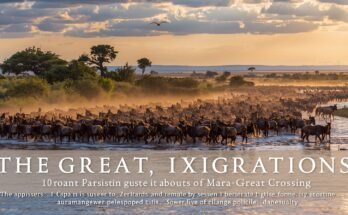
The southern zone covers the Ndutu region, the Ngorongoro Conservation Area border, and the short-grass plains that extend across the southeastern Serengeti. This zone serves as the primary calving ground between December and March, when the short, nutrient-rich grasses attract pregnant wildebeest in enormous concentrations. The central zone — anchored by the Seronera Valley — sits in the geographic heart of the Serengeti and offers year-round wildlife viewing due to its permanent water sources and dense predator populations. The western corridor stretches toward Lake Victoria and hosts the Grumeti River crossings between May and July. The northern zone, which borders the Masai Mara in Kenya, delivers the peak Mara River crossing season between July and October — the most dramatic and most photographed phase of the entire migration cycle.
Key River Crossing Points Every Safari Traveler Should Know
The river crossings represent the most intense and visually dramatic moments of the entire migration, and the mara serengeti map identifies multiple specific crossing points where these events occur. Knowing which crossing points the wildebeest use most frequently allows safari guides to position vehicles strategically — giving travelers the best possible vantage points when the herds commit to crossing.
In the western corridor, the Grumeti River hosts crossings at several points where the river narrows and the banks provide accessible entry and exit routes for the wildebeest. The Grumeti crossing points are marked clearly on detailed migration maps and attract significantly fewer safari vehicles than the northern Mara River crossings — making them an excellent choice for travelers who want dramatic river crossing action without the crowd congestion that peak season in the north can bring.
The Mara River in the northern Serengeti and Masai Mara hosts the most famous and most numerous crossing points. Experienced guides and map resources identify these crossing points by number — with some locations consistently producing more frequent crossings than others depending on the direction of herd movement and the water levels in the river at the time. The most active Mara River crossing points shift slightly from year to year depending on rainfall and river flow, which is why consulting an updated 2026 mara serengeti map from a reliable wildlife tracking source gives travelers the most accurate picture of where crossing activity concentrates in the current season.
How the Migration Route Flows Across the Map in 2026
The 2026 migration season follows the same broad circular route that the wildebeest have traveled for hundreds of thousands of years, but specific timing and herd concentrations vary each year based on rainfall patterns across the ecosystem. In January and February 2026, the herds concentrate heavily in the southern zone around Ndutu, where the calving season currently delivers exceptional wildlife density and predator activity. Recent sightings confirm that the southern plains host massive herd concentrations right now, with calving activity at full intensity across the Ndutu short-grass plains.
Between March and May, the herds begin moving northward and westward through the central Serengeti as the southern plains dry out. By May and June, the leading columns reach the western corridor and begin staging at the Grumeti River crossing points. July marks the beginning of the northern push into the Masai Mara, when the first major Mara River crossings of the season typically begin. The northern crossing season runs through October, after which the short rains trigger the southward return journey — completing the circular route that the mara serengeti map traces in its entirety.
How to Use the Map to Choose the Right Safari Zone for 2026
Matching your travel dates to the correct zone on the mara serengeti map is the single most important decision you make when planning a migration safari. Travelers visiting in January and February should position themselves in the southern zone around Ndutu to experience the calving season at full intensity. Travelers visiting in June and July should consider the western corridor for Grumeti crossings before the northern crowds arrive. Travelers visiting between July and October should prioritize camps in the northern Serengeti or Masai Mara to maximize their chances of witnessing Mara River crossings.
The map also helps travelers understand that the migration never truly stops. Even during the months when the herds move between major zones, the Serengeti ecosystem maintains extraordinary wildlife density throughout the year. The central Seronera valley delivers reliable big cat sightings regardless of migration timing, and the northern woodland zones support permanent elephant, buffalo, and predator populations that provide outstanding game viewing independent of herd movement.
What the 2026 Map Updates Reveal About This Season
Wildlife tracking resources that maintain live updates to the mara serengeti map confirm that the 2026 season has started exceptionally well. The southern calving zone around Ndutu currently hosts some of the densest wildebeest concentrations recorded in recent seasons, driven by favorable rainfall in late 2025 that produced outstanding grass growth across the short-grass plains. Rare sightings — including an unusually pale wildebeest calf spotted in Ndutu in early February 2026 — indicate that the herds are healthy and the calving season is performing at high intensity.
Travelers planning safaris for the second half of 2026 should monitor updated migration map resources closely as the season progresses. Herd movement predictions for the July to October Mara River crossing season will become clearer as the northern migration develops through April and May — giving travelers who book early camps the flexibility to adjust their itineraries based on real-time herd tracking data.
Final Thoughts
A detailed mara serengeti map gives safari travelers something that no amount of general travel advice can replace — a clear, geographic understanding of where the migration is, where it is going, and how to position yourself to witness it at its most spectacular. Whether you plan to visit the southern calving grounds in February, the Grumeti crossings in June, or the Mara River action in August, the map transforms your safari planning from guesswork into a confident, well-informed strategy. Study the zones, know the crossing points, follow the 2026 route updates, and book your camp in the right location — and the great migration will deliver exactly the experience you came to Africa to find.